
Agriculture
March 27, 2024
Esoko
Read SolutionImplemented by
Esoko
Updated on March 27, 2024
·Created on October 8, 2018
Drone mapping software for aerial crop analysis and precision agriculture.
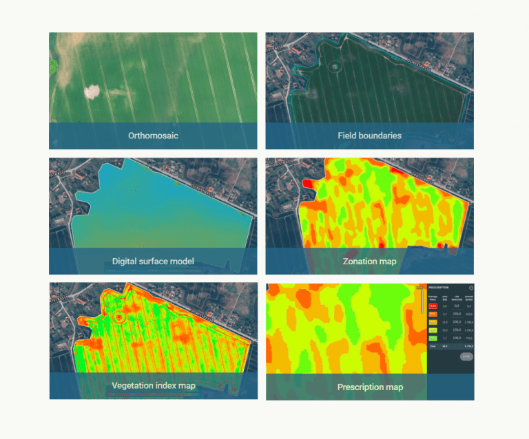
Pix4Dfields is a photogrammetry software designed for precision agriculture and crop analysis. It digitizes fields by converting drone images into orthomosaics, digital surface models, index maps, zones and prescription maps allowing maximization of operational efficiency.
Target SDGs
SDG 2: Zero Hunger
SDG 1: No Poverty
Market Suggested Retail Price
$2,600.00
Target Users (Target Impact Group)
Household
Distributors / Implementing Organizations
Pix4D
Manufacturing/Building Method
Software Development
Intellectural Property Type
Copyright
User Provision Model
Direct sales through webpage
Distributions to Date Status
Unknown
Design Specifications
Technical Support
Pix4D: online and phone
Replacement Components
N/A
Lifecycle
N/A
Manufacturer Specified Performance Parameters
Accuracy: consistent and comparable maps throughout the season Instant results: generation of high-resolution maps while in the field, without internet connection Agriculture intuitive: layer comparison, zone and prescription tools Collaboration: upload and access information between team members
Vetted Performance Status
Acquisition of plot statistical information (NDVI mean, median, stdev and min & max) from indices, helped understand the impact of different agricultural techniques over the crops. Pix4Dfield was updated with radiometric corrections, allowing to map bigger areas while reducing processing time. This reduces waiting times from several hours to minutes.
Safety
N/A
Complementary Technical Systems
Drones are required to capture the images that feed the software
Academic Research and References
Hovhannisyan, T., Efendyan, P., Vardanyan, M., 2018, Creation of a digital model of fields with application of DJI phantom 3 drone and the opportunities of its utilization in agriculture, Annals of Agrarian Science, Volume 16, Issue 2, , ISSN 1512-1887, Pages 177-180
Barrero, O., Perdomo, S., 2018, RGB and multispectral UAV image fusion for Gramineae weed detection in rice fields, Precision Agric
Maguire, M., Woldt, W., Neale, C., Frew, E., Meyer, G., 2017, A Survey of Agricultural Image Processing for Unmanned Aircraft Systems, ASABE Annual International Meeting
Yang, C., Suh, C., Westbrook, J., 2017, Early identification of cotton fields using mosaicked aerial multispectral imagery, J Appl Rem Sens 11(1) 016008
Barrero, O., Rojas, D., Gonzalez, C., 2016, Weed detection in rice fields using aerial images and neural networks, 2016 XXI Symposium on Signal Processing, Images and Artificial Vision (STSIVA), Bucaramanga, pp. 1-4
Ihsan, M., Somantri, L., Sugito, N., Himayah, S., Affriani, A., The Comparison of Stage and Result Processing of Photogrammetric Data Based on Online Cloud Processing, , ,
Compliance with regulations
N/A
Evaluation methods
Field tests with different organizations
Other Information
Pix4Dfields knowledge base
Agriculture
March 27, 2024
Implemented by
Esoko
Agriculture
January 17, 2024
Implemented by
Futurepump Ltd.

Agriculture
January 5, 2024
Implemented by
Technology for Tomorrow (T4T) Africa
Agriculture
January 22, 2024
Implemented by
Proximity Designs
Agriculture
February 1, 2024
Implemented by
Full Belly Project
Agriculture
January 22, 2024
Implemented by
Marius Rossouw design engineer Aflastop
Agriculture
February 12, 2024
Implemented by
Naireeta Services

Agriculture
February 26, 2024
Implemented by
FOPO
Agriculture
January 22, 2024
Implemented by
Sparky Social Enterprise Ltd.
Agriculture
January 30, 2024
Implemented by
D.S. Khuridiya
Have thoughts on how we can improve?
Give Us Feedback