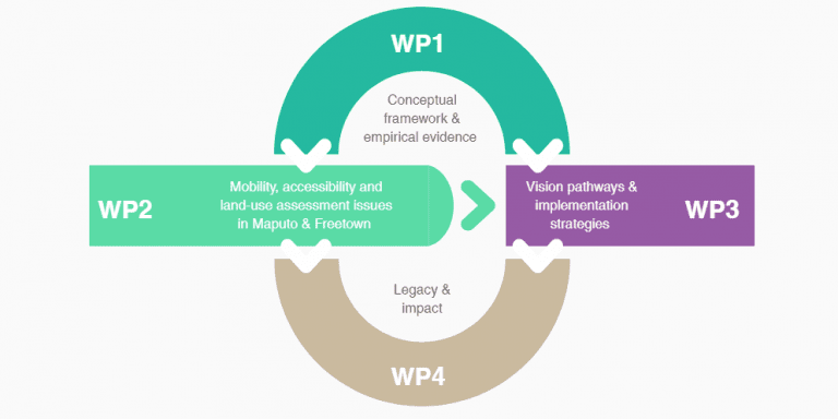
September 25, 2020

Eight Innovations Changing Urban Mobility and Transportation

This article is part of a series by students in the Sustainable Development program at Lehigh University in Bethlehem, Pensylvania (USA). The articles reveal snapshots of technology that is improving lives and environmental sustainability in the world’s cities. For more in the series:

Nine Digital Innovations that Improve City Life Worldwide

Twelve Apps Making Cities Accessible to Travelers and Immigrants

Ten Apps and Creative Technologies for Greener Urban Living


Idle in Los Angeles’ traffic or cross an intersection on foot in Kathmandu for first-hand evidence of the worldwide struggle between transportation systems and rising urban populations. Cities are growing larger, faster, and more densely populated. By 2050, 68 percent of the world’s population is expected to live in cities, The United Nations Department of Economic and Social Affairs estimates. One of the fundamental measures of a city’s success is its ability to provide efficient mobility throughout.

An emerging “smart” transportation market is taking some of the pressure off of the world’s urban transportation systems. This new market offers dynamic traffic management to improve efficiency on the road. It saves time by introducing parking management and guidance apps, reduces carbon dioxide emissions by fostering bike-friendly environments, and promotes an eco-friendly, integrated public transport system.

These are some of the smart city innovations meeting the demand for safer roads, faster commutes and fresher air. These solutions are shaping the future of urban transportation and mobility.

BestParking by ParkWhiz | Chicago, U.S. | EST. 2007

The biggest issue with parking isn’t the number of parking spots available, but rather the way they are managed. For instance, one study shows there are 2.2 million parking spaces in Philadelphia and 1.85 million in New York City, but people are struggling to find parking. To combat this inefficiency, BestParking helps you find parking by reserving a spot in a garage most convenient for you. All users do is download the mobile app, reserve a parking spot of your choice, pre-pay, drive to the garage, scan your mobile parking pass, and park. It’s simple. BestParking even offers investors an opportunity to generate revenue from their vacant parking. The service offers parking spots in all 50 US states and handles more than 1 million daily parking searches.

Learn more at: www.bestparking.com.

Smart Parking Node by Libelium | Zaragoza, Spain | 2019

Image: Libelium

Libelium takes a different approach to quicker parking. The company employs integrated radar technology to detect open parking spaces. Libelium’s new Smart Parking node detects spaces with 99 percent accuracy. The node can be installed in three ways, on the surface of the ground, semi-underground, and underground, allowing for more versatility. Once the device notices a change in the parking spot, it sends data to the cloud or a customer server, allowing for real-time parking updates. For drivers, Libelium’s Smart Parking solution can reduce the distance traveled while searching for parking by 30  percent, cut their search time by 43 percent, and their greenhouse gas emissions by 40 percent. The service can even reduce traffic volume by 8 percent. Libelium’s innovative parking solution improves city planning, urban mobility, and allocation of resources.

Learn more at: www.libelium.com/products/smart-parking.

U-Flow Traffic Sensor by Urbiotica | Barcelona, Spain

Peak traffic hours wreak havoc in cities with their corresponding accidents, delays and high carbon emissions. The chaos needs management, and the Internet of Things offers a solution in U-Flow traffic sensors by Urbiotica. U-Flow is a wireless sensor that detects traffic volume and vehicles’ average speed, then classifies them by size and by speed. The integration into existing traffic management systems allows for the device to be installed in city streets, freeways, and entrances and exits of parking spaces. U-Flow detects, processes and stores the information, then relays the information to be used for applications such as advanced decision algorithms and intelligent traffic management.

Learn more at: www.urbiotica.com/en/producto/u-flow-3.

Starfinder | Ontario, Canada | 2010

Cities need up-to-the second timetables to optimize public transportation. Starfinder delivers with its compact real-time locator device that can track vehicles, provide reports, alerts, and diagnostics of each vehicle’s movement. Tracking the speed of vehicles, cities can determine optimal routes and traffic allocation for more timely access to transportation. The data help public transportation adminstators and also residents seeking a ride.

Learn more at: laipac.com/starfinder-lite.

Moovit | Ness Ziona, Israel | 2011

The mobility app Moovit provides real-time arrival information at bus stops and train stations in more 3000 cities around the world. Moovit is revolutionizing urban transport by providing mobility as a service. The app analyzes and manages the world’s largest repository of transit data. Using data to gain insight about where, when, and how people are moving around cities makes Moovit the mobility service of the future.

Learn more at: company.moovit.com.

E-Bike Management System by SITAEL | Italy

The future of biking is smart. ESB is the first Internet of Things solution for e-bikes. The suite integrates in-depth vehicle, mobile and cloud-computing technologies into one system. The ESB smartphone app connects to the electronics embedded in the e-bike to enable features such as an anti-theft system, remote check and geolocation, crash detection and emergency call, routes, social activity, and even remote diagnosis. The vehicle connection to the cloud is done through bluetooth or GPS/GPRS depending on the electronics embedded in the e-bike. The future of city biking is this kind of deep integration of smart technology, providing riders with a hassle-free experience.

Learn more at: www.esb.bike.

Strava | San Francisco, California, US | 2009

Getting people to bike can be difficult, but the mobile app Strava meets that challenge by turning cycling into a social event. Strava is a cycling app that allows you to track your routes, times, frequency of travel and other aspects of the bike ride. By turning every iPhone and Android into a cycling computer via their mobile app, Strava allows you to measure your performance metrics while syncing with GPS watches, head units, heart rate monitors or even power meters. The app also records performance metrics and allows you to share your activity to a feed where friends and followers can share their workouts as well. This app merges smart technologies with social interaction and competition to increase the number of cyclists and make the activity more fun.

Learn more at: www.strava.com.

Starling Crossing| South London | 2017

Images: Umbrellium

The pedestrian fatality rate in the United States has soared since 2009. While there is no single factor behind this trend, one of the primary factors is the use of smartphones. Despite being banned for drivers, pedestrians are increasingly distracted while walking by using their device.

Pedestrian Fatalities in the United States from1990-2018. Image: Governors Highway Safety Association


Umbrellium’s solution is an interactive pedestrian crossing that responds in real-time to make pedestrians and road users more cognizant of each other. Starling Crossing (STigmergic Adaptive Responsive LearnING Crossing) dynamically reacts to road conditions to best prioritize pedestrian safety. With the road surface monitored by cameras and embedded with LEDs, if a person is fixated on their mobile device and comes in close proximity with a moving vehicle, a warning system will appear to ensure they are aware of the potential dangers. Even more so, if a child runs onto the road or a pedestrian runs across the street, markings on the road will appear with a trajectory of the person, alerting the driver of the dangerous situation. With a wealth of potential, Starling Crossing aims to enhance the perceptual awareness of pedestrians, cyclists, and drivers without distracting them.

Learn more at: umbrellium.co.uk/case-studies/south-london-starling-cv.

These innovations are supporting the urban transformation into the next generation of smart cities. The future of mobility and transportation is not contingent wholly upon the reformation of a city’s infrastructure, but also on value-added products and smart innovations that can transform the way cities mobilize and travel. Smart city innovations transform transportation, making it more readily available, efficient, convenient, and sustainable.


About the Author

Tommy Persaud is a student of Computer Engineering at Lehigh University. He is involved in the Global Citizenship Program and the Global Social Impact Fellowship.

Leave a Reply

Join a global community of changemakers.

Become A Member