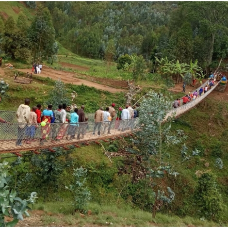
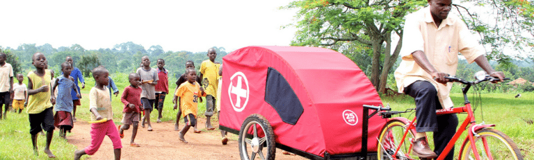
December 10, 2020

Research Brief: Low-Cost Cameras and Open-Source Algorithms Track Bridge Use in Rural Rwanda

Motion-activated digital cameras can effectively measure traffic across trail bridges in low-resource settings, according to new research. The Mortenson Center in Global Engineering (MCGE) at the University of Colorado Boulder (USA) developed and validated the efficacy of the cameras in combination with open-source computer vision algorithms for measuring the use of bridges in rural Rwanda. Dr. Evan Thomas, Director of MCGE, and colleagues reported their findings in October in the open-access journal PLOS ONE.

See also: Trailbridges May Have A Far Broader Impact Than Once Thought

“The analysis presented in this paper suggests that bridge use is not dependent on rainfall, potentially indicating that communities prefer the trail bridges to alternative or baseline river crossings. However, while no rainfall dependence on bridge use was observed, further investigation is required to establish if there are any seasonal attributes to bridge use (such as harvest) or extreme weather events (flooding),” the researchers write in their paper.

MCGE was brought on to lead an impact evaluation of Rwandan trail bridges built by the non-profit organizataion Brides to Prosperity (B2P). This work is in collaboration with researchers at Yale University, Arizona State University and Synaptiq. Sally Gerster, a graduate of a Masters in engineering program at the University of Colorado Boulder led the field work.

From E4C’s Solutions Library: Bridges to Prosperity Construction Manual

B2P builds trail bridges in rural Rwanda to provide easier access to roads for isolated communities. Isolation caused by lack of transportation infrastructure affects almost every facet of life for the rural poor. Trail bridges can improve access to critical services such as health care, schools, and markets. The World Bank estimates that nearly a billion people worldwide lack access to an all-season road within two kilometers, illustrating the scope of the problem, and the challenge of addressing it at scale.

In response, B2P has constructed more than 340 trail bridges in 21 countries. Seventy-five of these bridges are in Rwanda. In 2019, B2P signed a five-year memorandum of understanding with the Government of Rwanda to build several hundred more. This rapid program growth presents an unprecedented opportunity for rigorous investigation of the effect of new trail bridges on a number of key economic, health, agricultural and educational outcomes in rural communities.

From E4C Webinars: How to Measure the Impact of Rural Infrastructure in Emerging Economies

A variety of technologies and analysis methods have been deployed and validated to count pedestrians, bicycles and vehicles crossing bridges and other transportation infrastructure. These methods include in-person observational counting, motion-activated counters, magnetic inductive loops, infrared light beams, pressure pads, thermal cameras, and digital video and imagery analysis. These methods have been almost entirely deployed in high-income urban settings and often use technologies that would be cost-prohibitive or infeasible in a rural, low-income setting. Bridges to Prosperity’s standard bridge use monitoring methods typically rely on manual, in-person data collection, which is time-consuming, produces temporally limited data and is labor intensive. In order to identify and track trends and magnitude of bridge use, a continuous and automated method was needed.

Before conducting a full-scale evaluation, MCGE’s research team conducted a matched-cohort study of 12 bridge sites and 12 comparison sites over a 12-month period in 2019-2020. As part of this pilot study, researchers installed sensors at the 12 bridge sites to monitor bridge use, allowing for exploration of the correlation between bridge use and outcomes of interest.

As described in the study, MCGE developed, implemented and validated a novel method using low-cost cameras and open-source algorithms to measure bridge use. Read the paper for more on the technology deployed, the computer vision supported detection algorithm, a human-validated error estimate, and early findings of bridge use patterns.

Funding for this work was provided by the Autodesk Foundation.

Source: Computer vision supported pedestrian tracking: A demonstration on trail bridges in rural Rwanda, PLOS ONE, October 26, 2020

For a summary of the at colorado.edu work please see: Mortenson Center leading work to study trail bridge use in rural Rwanda

    Leave a Reply

    Join a global community of changemakers.

    Become A Member