Agriculture
June 8, 2024
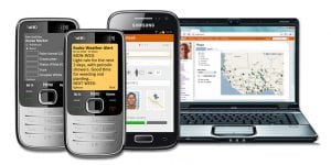
Mobile Obstetrics Monitoring (MOM)
Read SolutionImplemented by
Philips
Updated on June 23, 2024
·Created on September 28, 2019
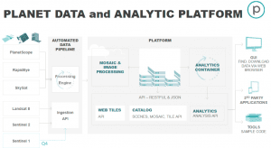
This web application provides digital cartography from a range of spatial resolution, wavelengths, and worldwide locations.
Planet Monitoring offers a selection of digital cartography with a wide range of spatial and temporal resolution and a multi-band spectrum. The applications of the cartography are scoped for different applications: measuring agricultural yields, monitoring natural resources, or aiding first responders after natural disasters.
Planet Labs has 6 headquarters situated in 4 countries (Canada, Germany, Netherlands and USA).
Target SDGs
SDG 2: Zero Hunger
SDG 3: Good Health and Well-Being
Target Users (Target Impact Group)
Small and Medium-sized Enterprises, Public Sector Agencies, NGOs
Distributors / Implementing Organizations
Planet Labs
Regions
Worldwide
Manufacturing/Building Method
N/A
Intellectural Property Type
Patent
User Provision Model
Download directly from manufacturer's website, trial version available
Distributions to Date Status
Unknown
Power requirement (mA)
Fixed or occasional power supply, depending on the device used
Processing platform
QGIS, ArcMap, Gvsig, SNAP
Remote Sensor Calibration (Y/N)
No
Reporting modalities (wifi/ cellular network/other)
Wifi
Sampling rates (Hz)
0.001-10,000,000 Hz
Sensor type(s)
Satellites
Design Specifications
The characteristics of the different digital cartography products are dependent on the selected satellites and therefore the require products (Consult the imagery products specifications). Some general details include:
Flexible Monitoring Options:
PlanetScope and SkySat Monitoring satellite images available, and can be tailored:
Product Schematics
Technical Support
Planet Labs help center
Replacement Components
N/A
Lifecycle
N/A
Manufacturer Specified Performance Parameters
Supporting economical and humanitarian activities in diverse areas, including agriculture, defense, energy, insurance, and maritime.
Vetted Performance Status
(Product specifications) PlanetScope: 3 m resolution SkySat Monitoring : 72 cm resolution
Safety
N/A
Complementary Technical Systems
None
Academic Research and References
Clough, C., Nair, R., Manso, J.M., George, M. and Erinjippurath, G., 2019, Planetary Scale Monitoring of Urban Growth in High Flood Risk Areas, Proceedings of the 36th International Conference on Machine Learning, Long Beach, California, PMLR 97.
Boshuizen, C.R., Mason, J., Klupar, P. and Spanhake, S., 2014, Results from the Planet Labs Flock Constellation, Planet Labs Inc., 28th Annual AIAA/USU Conference on Small Satellites.
Nag, S., Rios, J.L.,2015, Gerhardt., D. and Pham, C., CubeSat Constellation Design for Air Traffic Monitoring, Acta Astronautica, 128, pp. 180-193.
Butler, D., 2014, Many Eyes on Earth, In Focus News, Earth Science, ed. Macmillan Publishers Limited.
Hand, E., 2015, Startup Liftoff, Science, J Sci, AAAS, 348(6231).
“Planet Monitoring – Satellite Imagery and Monitoring.” n.d. Planet. Accessed June 23, 2024. https://www.planet.com/products/satellite-monitoring/
“ASF Home.” 2022. Alaska Satellite Facility. November 22, 2022. https://asf.alaska.edu/
“Earth Observation Constellation Methodology & Applications.” n.d. Justia.Com. Accessed June 23, 2024. https://patents.justia.com/patent/20140027576
Boshuizen, Christopher, William Marshall, James Mason, and Robert Schingler Jr. 2014. Earth Observation Constellation Methodology & Applications. 20140027576:A1. US Patent, filed July 24, 2013, and issued January 30, 2014. https://patents.google.com/patent/US20140027576A1/en
“Get Started With.” n.d. Planet. Accessed June 23, 2024. https://www.planet.com/get-started/
“Descarga QGIS.” n.d. Qgis.Org. Accessed June 23, 2024. https://qgis.org/es/site/forusers/download.html
“Inicio – Portal GvSIG.” n.d. Gvsig.Com. Accessed June 23, 2024. http://www.gvsig.com/es
“SNAP.” n.d. Esa.Int. Accessed June 23, 2024. https://step.esa.int/main/toolboxes/snap/
N.d. Planet.Com. Accessed June 23, 2024. https://assets.planet.com/docs/combined-imagery-product-spec-final-august-2019.pdf
“Welcome to Planet Support.” n.d. Planet.Com. Accessed June 23, 2024. https://support.planet.com/hc/en-us
Compliance with regulations
Unknown
Evaluation methods
Evaluated for resolution
Agriculture
June 8, 2024
Implemented by
Philips
Agriculture
March 8, 2024

Agriculture
June 24, 2024
Implemented by
Tiny Totos
Agriculture
February 16, 2024
Implemented by
Eniware
Agriculture
May 24, 2024
Implemented by
Esoko

Agriculture
February 8, 2024
Implemented by
Design That Matters (DtM)
Agriculture
January 10, 2024
Implemented by
NativeEnergy
Agriculture
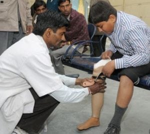
December 1, 2023
Implemented by
SMS Medical College Hospital (Ram Chandra Sharma with the team of doctors)

Agriculture
January 2, 2024
Implemented by
Klorfasil
Agriculture
December 29, 2023
Implemented by
RealRelief
Have thoughts on how we can improve?
Give Us Feedback