Agriculture
June 13, 2024
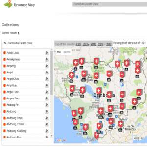
Resource Map
Read SolutionImplemented by
Resource Map
Updated on June 13, 2024
·Created on September 3, 2020
ArcGIS is a GIS software for the creation and use of spatial maps.
ArcGIS is a set of products offered by Esri and designed for spatial analysis.
Inside ArcGIS the following products are at service:
Esri offers several training options and resources, some of them free.
Another resource offered is ArcGIS Living Atlas of the World, a compilation of ready-to-use spatial data resources that can be combined with the users’ datasets. Some examples of available data types are imagery, base maps, demographic and transportation datasets.
Target SDGs
SDG 16: Peace, Justice and Strong Institutions
SDG 8: Decent Work and Economic Growth
Market Suggested Retail Price
$125.00
Target Users (Target Impact Group)
Household, Community, Small and Medium-sized Enterprises, Public Sector Agencies, NGOs
Distributors / Implementing Organizations
The distributor of ArcGIS is Esri. ArcGIS is used by individuals, institutions, and NGOs, some examples are BEGE-RDC, Blue Raster, Direct Relief, Aid Data, and Development Gateway.
Competitive Landscape
Direct competitors include QGIS.
Regions
Worldwide
Manufacturing/Building Method
Software development
Intellectural Property Type
Copyright
User Provision Model
Esri offers options for-profit and non-profit applications. Whether the user's application is for or non-profit the software is directly acquired from the manufacturer. Different license types are available according to the size of the company/non-profit. Here are some more details on for-profit licenses and non-profit licenses specifics.
Several of Esri's products such as ArcGIS Online, ArcGIS Desktop, and ArcGIS Enterprise are available at no cost for NGOs. Some of the possibilities include free access to the Living Lab, Story Maps, ArcGIS Marketplace, and MyMap tools.
ESRI also supports NGOs by offering free registration to the GIS Conference and other events. There is also access to community support through Esri Support Services. Non-profit users have reported receiving free support for training and events. Details on eligibility for Esri's NGO Program can be found on Esri's website.
Distributions to Date Status
It is uncertain how many users take advantage of ArcGIS services. Nonetheless, the annual Developer Summit and User Conference, held by Esri had 17,000 people attending - one of the largest gatherings in this field.
Geocoding supported (Y/N)
Yes
Visuals
Yes
Application
Transportation systems design, management, and analysis, general project management, spatial analysis
Type of data collected
GIS data
Data acquisition methods
Integration with APIs, import and export
Open source code (Y/N)
No
Open source data (Y /N/ Other)
No
Data import/export formats
ArcGIS products support two main GIS formats: vector and raster data formats. Vector data format can be presented in the form of points lines or polygons, while raster data concerns surfaces, including for example aerial/satellite imagery.
A full list of the specific extensions supported can be found here.
Telecommunication service required (Y/N)
No
Device(s) required
Computer
Languages available (list)
Full list can be found on ArcGis website.
Design Specifications
ArcGIS has been growing over the years and has been including several features to its products. The list of possibilities ranging from data collection and spatial analysis is immense. Some of the possibilities of ArcGIS software are enlighted below:
For reference, check the FAQ list.
For developers, there are several APIs and SDKs available more information can be found arcgis.
Technical Support
Esri provides training sessions on a regular basis through Esri Academy, there are options available for individuals and organizations. Training can be held in person or online, and there are also options for users who need a tailored course.
There are several resources in the Esri Academy that can be accessed freely. Special offers and discounts can apply to NGOs or to other partner organizations for specific courses. Users have reported having received support in specific projects.
Replacement Components
N/A
Lifecycle
N/A
Manufacturer Specified Performance Parameters
To provide solutions for:
Vetted Performance Status
Direct Relief conveyed the details of their aid operation in Haiti through an interactive map application based on ArcGIS. A research team, from Villanova University Puerto Rico, focusing on environmental studies and water standards reported being able to collect, store, and share data in real-time more systematically through the use of ArcGIS services. The report also mentions the ability to leverage the analysis of the collected data, to the extent of including the watershed's dynamic environment, and the impacts of major storm events.
Safety
Esri provides comprehensive documentation regarding legal and safety matters, including information on:
All information concerning legal matters can be found on the website.
Complementary Technical Systems
N/A
Academic Research and References
Scott, L.M., Janikas, M.V., 2010, Spatial statistics in ArcGIS, Fischer M., Getis A. (eds) Handbook of Applied Spatial Analysis. Springer, Berlin, Heidelberg
Thieler, R., Himmelstoss, E., Zichichi, J., Ergul, A., The digital shoreline analysis system (DSAS) version 4.0 – an ArcGIS extension for calculating shoreline change, Open-File Report 2008-1278, Prepared in cooperation with Innovate! Inc.
Marinoni, O., 2004, Implementation of the analytical hierarchy process with VBA in ArcGIS, Computers & Geosciences, Volume 30, Issue 6, Pages 637-646, ISSN 0098-3004
Olivera, F., Valenzuela, M., Srinivasan, R., Choi, J., Cho, H., Koka, S., Agrawal, A., 2007, ARCGIS?SWAT: A GEODATA MODEL AND GIS INTERFACE FOR SWAT1, Journal of the American Water Resources Association (JAWRA), Paper No. 04087
Zhan, X., Huang, M., 2004, ArcCN-Runoff: an ArcGIS tool for generating curve number and runoff maps, Environmental Modelling & Software, Volume 19, Issue 10, Pages 875-879, ISSN 1364-8152
“GIS Mapping Software, Location Intelligence & Spatial Analytics.” n.d. Esri.Com. Accessed June 13, 2024. https://www.esri.com/en-us/home
“BUREAU D’ETUDE GEOLOGIQUE ET ENVIRONNEMENTALE (BEGE-RDC).” n.d. Bege-Rdc.Org. Accessed June 13, 2024. http://www.bege-rdc.org/
“Blue Raster.” n.d. Blue Raster. Accessed June 13, 2024. https://www.blueraster.com/
“AidData — A Research Lab at William & Mary.” n.d. Aiddata.Org. Accessed June 13, 2024. https://www.aiddata.org/
“Development Gateway: An IREX Venture – Data and Digital Solutions for International Development.” 2020. Development Gateway: An IREX Venture. July 29, 2020. https://developmentgateway.org/
“Pricing.” n.d. ArcGIS Developers. Accessed June 13, 2024. https://developers.arcgis.com/pricing/
“Nonprofit Software Discounts.” n.d. Esri.Com. Accessed June 13, 2024. https://www.esri.com/en-us/industries/nonprofit/nonprofit-program?rsource=https%3A%2F%2Fwww.esri.com%2Fen-us%2Fsolutions%2Findustries%2Fsustainability%2Fnonprofit-program%2Foverview
“QGIS.” n.d. Qgis.Org. Accessed June 13, 2024. https://qgis.org/en/site/
“Goal 16.” n.d. Sdgs.Un.Org. Accessed June 13, 2024. https://sdgs.un.org/goals/goal16
“ArcGIS for Student Use.” n.d. Esri.Com. Accessed June 13, 2024. https://www.esri.com/en-us/arcgis/products/arcgis-for-student-use/overview
“Mapping Solutions.” n.d. Esri.Com. Accessed June 13, 2024. https://www.esri.com/en-us/arcgis/products/arcgis-solutions/overview.
“Developer Subscriptions.” n.d. ArcGIS Developers. Accessed June 13, 2024. https://developers.arcgis.com/pricing/build-arcgis-solutions/
ArcGIS Living Atlas of the World. n.d. “ArcGIS Living Atlas of the World.” Arcgis.Com. Accessed June 13, 2024. https://livingatlas.arcgis.com/en/home/
“ArcGIS StoryMaps.” n.d. ArcGIS StoryMaps. Accessed June 13, 2024. https://storymaps.arcgis.com
“ArcGIS – My Map.” n.d. Arcgis.Com. Accessed June 13, 2024. https://www.arcgis.com/home/webmap/viewer.html?center=20%2C45
N.d. Esri.Com. Accessed June 13, 2024. https://www.esri.com/content/dam/esrisites/en-us/esri-press/book-pages/sample-page/the-arcgis-book-second-edition-companion-resource.pdf
“Supported Formats.” n.d. Esri.Com. Accessed June 13, 2024. https://www.esri.com/en-us/arcgis/products/arcgis-data-interoperability/supported-formats
“Set Language and Region—ArcGIS Online Help.” n.d. Arcgis.Com. Accessed June 13, 2024. https://www.esri.com/en-us/arcgis/products/arcgis-data-interoperability/supported-formats
“FAQ—ArcGIS Online Help.” n.d. Arcgis.Com. Accessed June 13, 2024. https://doc.arcgis.com/en/arcgis-online/reference/faq.htm
“Esri Training.” n.d. Esri.Com. Accessed June 13, 2024. https://www.esri.com/training/
“Esri Training Options for Individuals.” n.d. Esri.Com. Accessed June 13, 2024. https://www.esri.com/training/training-for-individuals/
“Esri Training Options for Organizations.” n.d. Esri.Com. Accessed June 13, 2024. https://www.esri.com/training/training-for-organizations/
“From Paper to Maps and Apps.” n.d. Esri.Com. Accessed June 13, 2024. https://www.esri.com/en-us/landing-page/industry/water/2019/from-paper-to-maps-and-apps
“Maintenance & Support Program and Product Lifecycle Support Policy.” n.d. Esri.Com. Accessed June 13, 2024. https://www.esri.com/en-us/legal/terms/maintenance
“Services Terms of Use.” n.d. Esri.Com. Accessed June 13, 2024. https://www.esri.com/en-us/legal/terms/services
N.d. Esri.Com. Accessed June 13, 2024. https://www.esri.com/content/dam/esrisites/en-us/media/legal/ma-full/ma-full.pdf
“Data Attributions and Terms of Use.” n.d. Esri.Com. Accessed June 13, 2024. https://www.esri.com/en-us/legal/terms/data-attributions
“Esri Legal.” n.d. Esri.Com. Accessed June 13, 2024. https://www.esri.com/en-us/legal/overview
“Compliance.” n.d. Arcgis.Com. Accessed June 13, 2024. https://trust.arcgis.com/en/compliance/compliance-tab-intro.htm
Compliance with regulations
ArcGIS provides compliance information on the following topics:
Evaluation methods
Field trials, applications, and website design and integration.
Other Information
Crowdsourcing for NGOs and Non profits: Webinar, can be watched here.
Agriculture
June 13, 2024
Implemented by
Resource Map
Agriculture
June 13, 2024
Implemented by
Pajat Solutions Ltd

Agriculture
June 23, 2024
Implemented by
MAPS (Mobile Agricultural Power Solutions)

Agriculture
December 18, 2024
Implemented by
SkyWind Energy GmbH
Agriculture
June 4, 2024
Implemented by
Imperial College London

Agriculture
June 19, 2024
Implemented by
Inmarsat

Agriculture
June 19, 2024
Implemented by
Internet-in-a-box
Agriculture
January 21, 2024
Implemented by
Mali Biocarburant SA

Agriculture
June 22, 2024
Implemented by
Mellowcabs (now MellowVans)

Agriculture
June 25, 2024
Implemented by
Media in Cooperation and Transition (MiCT)
Have thoughts on how we can improve?
Give Us Feedback