Agriculture
February 24, 2024
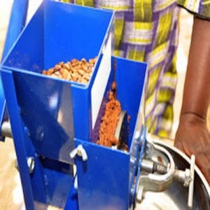
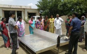
Multi-Crop Ewing Grinder
Read SolutionImplemented by
Compatible Technology International
Updated on June 14, 2024
·Created on October 8, 2018
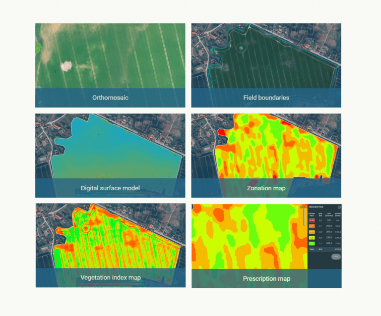
Drone mapping software for aerial crop analysis and precision agriculture.
Pix4Dfields is a photogrammetry software designed for precision agriculture and crop analysis. It digitizes fields by converting drone images into orthomosaics, digital surface models, index maps, zones and prescription maps allowing maximization of operational efficiency.
Target SDGs
SDG 2: Zero Hunger
SDG 1: No Poverty
Market Suggested Retail Price
$2,600.00
Target Users (Target Impact Group)
Household
Distributors / Implementing Organizations
Pix4D
Regions
Worldwide
Manufacturing/Building Method
Software Development
Intellectural Property Type
Copyright
User Provision Model
Direct sales through webpage
Distributions to Date Status
Unknown
Geocoding supported (Y/N)
Yes
Visuals
2D Orthomosaic, 2D Digital Surface Model, Vegetation Index Maps, Zonation Maps, Prescription Maps
Application
Crop scouting, protection and production analysis
Type of data collected
Field and crop data
Data acquisition methods
Drone images
Open source code (Y/N)
No
Open source data (Y /N/ Other)
No
Data import/export formats
Inputs: JPEG images, Monochromatic TIFF, Multi-band TIFF (RGB / Infrared / thermal), 1 layer (no pyramid, no multi-page), 8, 10, 12, 14, 16 bit integer, floating point
Outputs: Orthomosaic (GeoTIFF file) and Index map (GeoTIFF file)
Telecommunication service required (Y/N)
No internet required
Device(s) required
Laptop, drone, cameras
Languages available (list)
English
Design Specifications
Technical Support
Pix4D: online and phone
Replacement Components
N/A
Lifecycle
N/A
Manufacturer Specified Performance Parameters
Accuracy: consistent and comparable maps throughout the season
Instant results: generation of high-resolution maps while in the field, without internet connection
Agriculture intuitive: layer comparison, zone and prescription tools
Collaboration: upload and access information between team members
Vetted Performance Status
Acquisition of plot statistical information (NDVI mean, median, stdev and min & max) from indices, helped understand the impact of different agricultural techniques over the crops. Pix4Dfield was updated with radiometric corrections, allowing to map bigger areas while reducing processing time. This reduces waiting times from several hours to minutes.
Safety
N/A
Complementary Technical Systems
Drones are required to capture the images that feed the software
Academic Research and References
Hovhannisyan, T., Efendyan, P., Vardanyan, M., 2018, Creation of a digital model of fields with application of DJI phantom 3 drone and the opportunities of its utilization in agriculture, Annals of Agrarian Science, Volume 16, Issue 2, , ISSN 1512-1887, Pages 177-180
Barrero, O., Perdomo, S., 2018, RGB and multispectral UAV image fusion for Gramineae weed detection in rice fields, Precision Agric
Maguire, M., Woldt, W., Neale, C., Frew, E., Meyer, G., 2017, A Survey of Agricultural Image Processing for Unmanned Aircraft Systems, ASABE Annual International Meeting
Yang, C., Suh, C., Westbrook, J., 2017, Early identification of cotton fields using mosaicked aerial multispectral imagery, J Appl Rem Sens 11(1) 016008
Barrero, O., Rojas, D., Gonzalez, C., 2016, Weed detection in rice fields using aerial images and neural networks, 2016 XXI Symposium on Signal Processing, Images and Artificial Vision (STSIVA), Bucaramanga, pp. 1-4
Ihsan, M., Somantri, L., Sugito, N., Himayah, S., Affriani, A., The Comparison of Stage and Result Processing of Photogrammetric Data Based on Online Cloud Processing, , ,
“Agricultural Drone Mapping: Crop Protection and Production.” n.d. Pix4D. Accessed June 14, 2024. https://www.pix4d.com/industry/agriculture/
“Pricing Plans for PIX4Dfields Agriculture Mapping Software.” n.d. Pix4D. Accessed June 14, 2024. https://www.pix4d.com/pricing/pix4dfields/
“AgOS —.” n.d. AgWorks. Accessed June 14, 2024. https://agworks.net/agos
Hype – Agriculture – Short 15s – Generic. 2021. https://www.dronedeploy.com/solutions/agriculture/
“Drone Ag: Farmers Who Know Drones – Software.” n.d. Drone Ag. Accessed June 14, 2024. https://droneag.farm/
“FarmMap4D – Map Your Place.” 2021. FarmMap4D – Map Your Place. July 12, 2021. https://www.farmmap4d.com.au/
“Agriculture.” n.d. Esri.Com. Accessed June 14, 2024. https://www.esri.com/en-us/industries/agriculture/overview
“THE 17 GOALS.” n.d. Sdgs.Un.Org. Accessed June 14, 2024. https://sdgs.un.org/goals
N.d. Ctfassets.Net. Accessed June 14, 2024. https://pix4d.com/wp-content/uploads/2018/06/Pix4Dfields_product_table.pdf
“PIX4Dfields: Drone Software for Agriculture Mapping.” n.d. Pix4D. Accessed June 14, 2024. https://www.pix4d.com/product/pix4dfields/
Pix4D. n.d. “Pix4D Account.” Pix4d.Com. Accessed June 14, 2024. https://account.pix4d.com/signup
“Pix4D Documentation.” n.d. Pix4d.Com. Accessed June 14, 2024. https://support.pix4d.com/hc/en-us#gsc.tab=0
“How Drone Mapping Makes On-Farm Test Plots Relevant.” 2017. Pix4D. December 5, 2017. https://pix4d.com/drone-mapping-making-on-farm-test-plots-even-more-relevant-for-everyone/
narinder. 2019. “BONUS: Drones in Agriculture – P4 Multispectral, Pix4DFields, and Optimum Workflow for Capturing Actionable Insights – Drone UTM.” Drone UTM. October 12, 2019. https://www.thedroneu.com/drones-in-agriculture-p4-multispectral-mapping/
“Mapping 100ha+ Rice Paddies with PIX4Dfields.” 2020. Pix4D. February 4, 2020. https://www.pix4d.com/blog/mapping-large-rice-paddies/
Compliance with regulations
N/A
Evaluation methods
Field tests with different organizations
Other Information
Pix4Dfields knowledge base
Agriculture
February 24, 2024
Implemented by
Compatible Technology International
Agriculture
September 11, 2024
Implemented by
MIT D-Lab
Agriculture
January 19, 2024
Implemented by
Godrej
Agriculture
August 21, 2024
Implemented by
Science for Society

Agriculture
June 1, 2024
Implemented by
Cafedirect Producers’ Foundation
Agriculture
February 5, 2024
Implemented by
Vestergaard
Agriculture
August 23, 2024
Implemented by
Bioguaviare
Agriculture
February 16, 2024
Implemented by
Agpulse Organics Pvt Ltd, Mr. Rajeev Ranjan
Agriculture
September 18, 2024
Implemented by
Greenhouse Ventures
Agriculture
August 23, 2024
Implemented by
Futurepump Ltd.
Have thoughts on how we can improve?
Give Us Feedback