Agriculture
February 6, 2024
Chameleon Soil Moisture Sensor
Read SolutionImplemented by
Australian Centre for International Agricultural Research
Updated on June 12, 2024
·Created on August 7, 2019
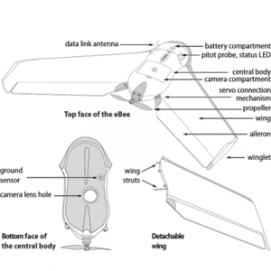
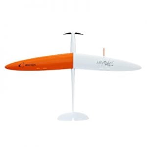
SenseFly eBee Classic is a fully autonomous drone used to capture high-resolution aerial photos.
SenseFly eBee Classic is a drone used to capture high-resolution aerial photos. It is fully autonomous, lightweight (700 g/1.5 lb) and contains an RGB camera, batteries, radio modem and eMotion software. Image processing software is optional.
The product is commercialized and widely used in agriculture, environmental monitoring, surveying & mapping and humanitarian activities such as emergency response and aid distribution.
Target SDGs
SDG 2: Zero Hunger
SDG 9: Industry, Innovation and Infrastructure
Target Users (Target Impact Group)
Public Sector Agencies, NGOs
Distributors / Implementing Organizations
Several distributors worldwide, for example most of Africa is served by the South African company Optron Ltd where one can request a demo/introduction, or Aimil Ltd in India. A list of nearest distributors per country is available at their website.
Competitive Landscape
Direct competitors include Delair DT18 AG, AgEagle RX40, and Skyfish M6 UAV.
Regions
Worldwide
Manufacturing/Building Method
The company is a commercial drone subsidiary of Parrot Group. It manufactures drone hardware and eMotion software complementing all its drone products including eBee Classic.
Intellectural Property Type
Trademark
User Provision Model
Authorized distributors
Distributions to Date Status
Unknown
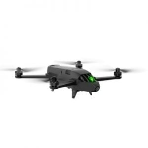
Drone type
Fixed wing
Weight (kg)
0.69 kg
Take off / Landing type
Hand launch/automatic landing
Carry case dimensions (m)
Carry-on size, approximately 0.56 m x 0.45 m x 0.25 m
GNSS system
Onboard GPS
Flight time (hour)
50 min
Cruise speed (km per hour)
40-90 km/hr
Battery type
Rechargeable lithium-polymer battery
Sensors available (Y/N)
Yes
Type of data collected
20 MP resolution images
Drone software platform
eMotion
Pix4D
Application
Agriculture, engineering, surveying and mapping, humanitarian applications, environmental monitoring
Design Specifications
Sensefly eBee features a hand launch, so that no catapult is required, and a rear-facing propeller for additional safety.
The 2.4 GHz radio link communicates with eMotion via USB ground modem. The communication link has approximately 3 km range.
Onboard artificial intelligence analyzes inertial measurements and GPS data to optimize the flight.
Product Schematics
Technical Support
Authorized service centers
Replacement Components
Battery
Lifecycle
12 months warranty or optional 24 months, with up to two non-warranty drone replacements, six battery replacements and other consumables, and two free 100-hour maintenance services
Manufacturer Specified Performance Parameters
Vetted Performance Status
A human impact test showed that the eBee drones have an impact of 8.75 J. An accuracy assessment showed the eBee RTK can achieve 3 cm horizontal and 5 cm vertical accuracy.
Safety
Unknown
Complementary Technical Systems
Flight planning & control software (supplied) eMotion
Image processing software (optional) Pix4Dmapper Pro
Academic Research and References
Roze, A., Zufferey, J.C., Beyeler, A. and McClellan, A., 2014, eBee RTK Accuracy Assessment, White Paper Sense Fly.
Fornace, K.M., Drakeley, C.J., William, T., Espino, F. and Cox, J., 2014, Mapping Infectious Disease Landscapes: Unmanned Aerial Vehicles and Epidemiology, Trends in Parasitology, 30(11), pp. 514-519.
Dvo?ák, P., Müllerová, J., Bartaloš, T. and Br?na, J., 2015, Unmanned Aerial Vehicles for Alien Plant Species Detection and Monitoring, International Archives of the Photogrammetry, Remote Sensing & Spatial Information Sciences, 40.
Drummond, Christopher D., Drummond, C., Harley, M., Turner, I., Matheen A., Nashwan A. and Glamore, W., 2015, UAV Applications to Coastal Engineering, Australasian Coasts & Ports Conference 2015: 22nd Australasian Coastal and Ocean Engineering Conference and the 15th Australasian Port and Harbour Conference.
Chianucci, F., Disperati, L., Guzzi, D., Bianchini, D., Nardinoc, V., Lastri, C., Rindinella, A. and Corona, P., 2016, Estimation of Canopy Attributes in Beech Forests Using True Colour Digital Images from a Small Fixed-Wing UAV, International Journal of Applied Earth Observation and Geoinformation, 47 , pp. 60-68.
Seymour, A. C., Dale J., Hammill M., Halpin P. N. and Johnston D. W., 2017, Automated Detection and Enumeration of Marine Wildlife Using Unmanned Aircraft Systems (UAS) and Thermal Imagery, Scientific Reports, 7, p. 45127.
Aimil Ltd. n.d. “Cement, Material Testing Instruments, Concrete Equipment, Civil Engineering – Aimil Ltd.” Aimil.Com. Accessed June 12, 2024. https://www.aimil.com
optron. 2017. “Advanced Geospatial Solutions.” OPTRON (Pty) Ltd. August 31, 2017. https://www.optron.com/
“Talk to Sales.” 2022. AgEagle Aerial Systems Inc. August 9, 2022. https://www.sensefly.com/talk-to-sales/
“Goal 2.” n.d. Sdgs.Un.Org. Accessed June 11, 2024. https://sdgs.un.org/goals/goal2
“Goal 9.” n.d. Sdgs.Un.Org. Accessed May 29, 2024. https://sdgs.un.org/goals/goal9
“Support.” 2022. AgEagle Aerial Systems Inc. July 28, 2022. https://ageagle.com/support/
“Always On.” 2022. AgEagle Aerial Systems Inc. August 2, 2022. https://www.sensefly.com/services/always-on/
Roze, A., J-C Zufferey, A. Beyeler, and A. Mc Clellan. n.d. “EBee RTK Accuracy Assessment.” Globalsurvey.Co.Nz. Accessed June 12, 2024. https://globalsurvey.co.nz/wp-content/uploads/2020/01/eBee_RTK_Accuracy_Assessment.pdf
Canada, Transport. n.d. “Transport Canada.” Canada.Ca. Accessed June 12, 2024. https://tc.canada.ca/en
“Resources.” 2022. AgEagle Aerial Systems Inc. July 20, 2022. https://ageagle.com/resources/
Butterworth-Hayes, Philip. 2019. “‘How We Achieved BVLOS Authorisations around the Globe.’” Unmanned Airspace. January 13, 2019. https://www.unmannedairspace.info/utm-industry-leader-interview/achieved-bvlos-authorisations-around-globe/
“List of Authorized RPAS Designs.” n.d. ANAC National Civil Aviation Agency – Brazil. Accessed June 12, 2024. https://www.anac.gov.br/en/drones/list-of-authorized-rpas-designs
“Resources.” 2022. AgEagle Aerial Systems Inc. July 20, 2022. https://ageagle.com/resources/
Compliance with regulations
Transport Canada: SenseFly's entire platform of professional drone solutions—eBee Classic, eBee SQ and eBee X—complies with the latest Transport Canada regulations for advanced drone operations in controlled airspace.
Beyond visual line of sight (BVLOS) regulatory requirements were satisfied in France, Spain, Denmark, Switzerland, Canada and China.
Brazil’s Civil Aviation Authority approved SenseFly Drones for country’s Beyond Visual-Line-Of-Sight (BVLOS) operations.
Evaluation methods
Whitepapers
Evaluated for accuracy and precision
Other Information
None
Agriculture
February 6, 2024
Implemented by
Australian Centre for International Agricultural Research

Agriculture
August 29, 2024
Implemented by
Weifang Public Machinery Co., Ltd.
Agriculture
September 12, 2024
Implemented by
KSNM
Agriculture
June 11, 2024
Implemented by
Honeycomb
Agriculture
June 12, 2024
Implemented by
Parrot
Agriculture
June 12, 2024
Implemented by
Delair Tech
Agriculture
February 6, 2024
Implemented by
SAYeTECH Ltd
Agriculture
February 2, 2024
Implemented by
Agro Vision
Agriculture
September 18, 2024
Implemented by
Alvan Blanch
Agriculture
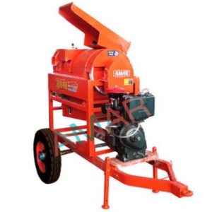
September 19, 2024
Implemented by
Amaragri
Have thoughts on how we can improve?
Give Us Feedback